Objective Comments and Analysis - All Science, No Politics
Primary Author Richard James
2010-2013 Author Rick Thoman
Tuesday, July 7, 2026
Hail Reports
Tuesday, September 9, 2025
Southeast Interior Heatwave
I was about to post a quick summary of August climate anomalies, but a more urgent imperative is to comment briefly on the remarkable heatwave of last Thursday in the southeastern interior (I overlooked it at the time). Here's the 500mb setup at 4pm Thursday, showing a tremendous ridge over northwestern Canada:
80°F in Northway is a record for September: the previous record was 79°F in 1982.
78°F in Eagle is close to a monthly record, but 80°F was observed on the 12th in 2021.
76°F in Gulkana is a tie for the warmest on record so late in the season; it seems there was a remarkably hot spell in early September 1917 (Eagle was also very warm at the same time). If not for that event, this would be a new monthly record.
Perhaps most remarkable of all, Chicken reached 80°F - the same location that dropped to 14°F only 5 days earlier. This is a remarkable feat, and it's worth a bit of research to see if such a temperature rebound to summer-like warmth has ever been observed anywhere in Alaska before. It certainly hasn't in Chicken (with data only back to 1997) - the previous warmest subsequent to a 14°F freeze was 71°F in 2012. In Northway it once reached 72°F after dropping to 12°F (in 1987), and it may have reached 74°F in Tok after a 14°F low (in 1989). But I'm not seeing anything close to 80°F. Needless to say, the 80°F is also a monthly record for Chicken (previously 72°F in 2019).
Tuesday, July 8, 2025
More Heat and Lightning
[Update July 10]
Rick Thoman pointed out that a SNOTEL site near Kobuk reached 93°F on Saturday, a remarkable temperature for this typically (slightly) more maritime area in the northwestern interior. (Note that SNOTEL thermometers are more reliable than the warm-biased RAWS instruments.)
But it was back down to 30°F yesterday morning - that's quite a change. Click to enlarge:
[end of update]
The second big heat wave of the summer for central and northern Alaska came to an end with a tremendous amount of lightning in the past couple of days. The ALDN recorded over 12,000 cloud-to-ground lightning strikes in the 24 hour period ending at 6am today, with several regions of strong activity:
Yesterday was the 5th day this summer with over 10,000 ground strikes recorded, and this is the most of any summer in the modern ALDN history since 2012 (note that this calculation includes northwestern Canada to the west of 129°W). Previously the record was 4 such days in both 2016 and 2017; but some summers don't see a single day this active - for example, the peak lightning day last summer was 6500 strikes on June 23.
In terms of total year-to-date strikes, 2025 remains in second place behind 2015.
Many new fires will have been started by this latest round of lightning, but the weather is now much cooler and more humid, which will greatly aid fire control efforts. There are two substantial fires between Fairbanks and Nenana, collectively called the Nenana Ridge Complex, with expansive evacuation orders in place. These fires have been burning since around June 20.
Looking back at the heat wave, it peaked over the holiday weekend, and was focused over the northern and northwestern interior, as well as the Brooks Range. After seeing its latest measurable snow on record (again) only 4 weeks earlier, Bettles reached 90°F on Saturday, and that's only the second 90°F this century at Bettles - the other was in 2019. Bettles is now running in second place for number of 80°F and 85°F days this summer (15 and 8 respectively). What a turn-around from the cold start to summer:
Up at Anaktuvuk Pass, the temperature reached or exceeded 80°F for 4 days in a row, which is quite extraordinary for the location (2100' elevation at 68°N). Even a single 80°F day is very unusual up there, but the count has now reached 6 days this summer; the previous record from recent decades (since the mid-1980s) is just 2 such days in 2016.
Tuesday, August 20, 2024
Heat and Floods
Wednesday, August 7, 2024
Arctic Coast Heat Record
Thursday, July 25, 2024
Extreme Weather in McGrath
Tuesday, June 15, 2021
Summer Heat
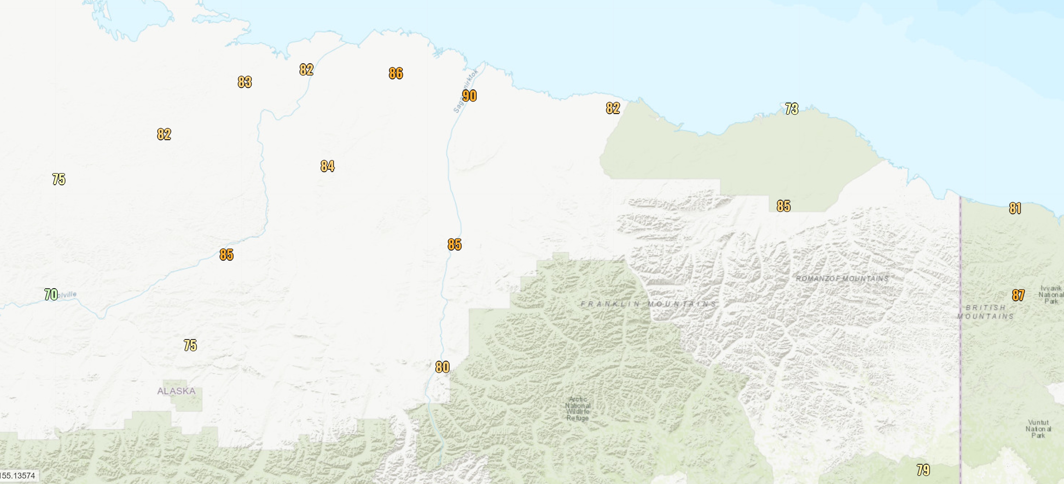
The heat is on for the eastern half of the interior today, with widespread 80s, including 83°F so far in Fairbanks and 84°F in Eagle. Many RAWS site are hotter, but that's typical under strong summer sunshine. More notable is the heat across the eastern North Slope: 72°F at Barter Island, and 80°F at Deadhorse on a southwest wind before the sea breeze kicked in. Click to enlarge:
The 80°F at Deadhorse is the first time in nearly 3 years that the temperature has exceeded 73°F. The calendar years of 2019 and 2020 had maximum temperatures of 73°F and 71°F respectively, which is actually the coolest pair of summers (by this metric) since 1987 and 1988. But all four years from 2015-2018 saw at least one 80°F day in Deadhorse. Here's a visual representation of all 75+ and 80+ days since 1970 in the combined history from Deadhorse and (prior to 1999) Prudhoe Bay.
It's interesting to note the occurrence of warm days in August - remarkably late in the summer for the Arctic coast - between 1989 and 2007. Also, the trend towards earlier hot days seems notable: prior to 1990, the earliest 75°F was July 3, and today was the earliest 80°F on record.
In other (but related) news, Fairbanks airport has been reporting distant wildfire smoke this afternoon: presumably the result of the Haystack fire 20 miles north of town. This is the first smoke report at the airport since June 1st of last summer, and that was the only day last year that reported smoke.
Monday, July 8, 2019
Heat and Smoke
There's far too much to comment on, but the remarkable July 4 heat in Anchorage may be the most astonishing statistic: the previous all-time record for the city's official climate site was only 85°F.
Dense smoke from wildfires has held temperatures down in some parts of the interior, including Fairbanks, but many locations in western and southern Alaska are well up into the 80s today. Particularly striking to me is the 87°F currently being reported from Noatak in the northwest - above the Arctic Circle - and 92°F earlier today at the high-quality CRN station to the southeast of Ruby.
Here's an annotated true-color satellite image, courtesy of Rick Thoman and UAF:
Nasty wildfire smoke blankets a fair chunk of Alaska. Smoke from the big fires west of McGrath inundated the lower Kuskokwim and Bristol Bay regions Sunday, and today the smoke has turned northward across western Norton Sound. #akwx @Climatologist49 @KYUKNews @kdlgradio @KNOMnews pic.twitter.com/GcxurQP7yW— Rick Thoman (@AlaskaWx) July 8, 2019
Click on the image below for a higher resolution version:
As bad as the smoke is at the moment in Fairbanks, this summer has a long way to go to equal the awful summer of 2004 in terms of duration and choking density of smoke - see the chart below, showing data from the Fairbanks airport ASOS instrument. Here's hoping that 2004 remains an outlier.
Sunday, June 11, 2017
Heat Update
94°F Tok 70SE
92°F Whitestone Farms COOP
91°F Tok #2 COOP (June 9 and June 10)
90°F North Pole COOP
90°F Ester 5NE COOP
90°F Fairbanks Intl AP
The Tok 70SE site experiences a remarkably continental climate with large diurnal temperature ranges in summer; the low temperature on Friday was 43°F, and just 3 days earlier it was 29°F.
Here are the temperatures recorded by the various thermometers at the CRN site, at 5-minute intervals from 5-6pm AKDT on Friday. The maximum of 34.3°C is 93.7°F; pretty impressive for the 9th of June.
Friday, June 9, 2017
Interior Heat Wave
Assuming the high temperature reaches 90°F in Fairbanks today [update: confirmed by NWS], this is quite a rare event; it happened in 2013 (two days), once in each of 2009 and 2010, but prior to that 90°F was not reached at all from 1995 through 2008. Today is almost but not quite the earliest in the year that 90°F has been reached; the only earlier occasion was May (!) 28 in 1947.
It's hard to imagine, but temperatures on the eastern North Slope this afternoon are actually below freezing; Barter Island has been hovering around 28°F all day. It was 23°F in Barrow this morning with clear skies and a strong breeze; it was a beautiful scene, but amazingly cool considering the heat on the other side of the Brooks Range.
The temperature difference we're seeing here between the North Slope and the interior is right at the limit of what has been observed historically at this time of year; for example, the largest difference in daily high temperatures between Fairbanks and Barrow is 58°F in June, and it looks like today's difference will be about 55°F (90°F vs 35°F).
The largest summer-time same-day high temperature difference between Fairbanks and Deadhorse/Prudhoe Bay is 55°F, which occurred in the late June heat wave of 2013 (92°F in Fairbanks, 37°F in Deadhorse). With the temperature reaching only 32°F so far today in Deadhorse, the record may be broken.
Monday, July 18, 2016
Heat Wave Review
Looking at 850mb temperatures, the Fairbanks soundings recorded a peak of 16.0°C, which is equal to the average maximum for the year. This is a little lower than the GFS model forecast was indicating, so the air mass didn't quite heat up as much as expected. Additionally, the surface temperature came a degree or two short of what might be expected based on the observed 850mb temperature, and this could be the effect of moist soil as I speculated earlier. Humidity was high, with the heat index reaching 87°F at the airport after the rain on Thursday afternoon; the heat index only gets this high about once every 5 years, on average.
Here's a map of the maximum temperatures observed during the hot spell, courtesy of the xmACIS2 interface at http://xmacis.rcc-acis.org. With one exception, all of the reports above 90°F are from RAWS stations, which are known to have a high bias in warm, sunny weather, because of inadequate ventilation of the thermometer. The highest plausible non-RAWS temperature is the 92°F reported on July 14 by the Two Rivers COOP observer, about 25 miles east of Fairbanks.
It's interesting to look at the evolution of the temperature profile as measured by the Fairbanks soundings during the hot spell; the animation below shows the twice-daily soundings from Tuesday morning through yesterday morning. The steady warming and then cooling of the lower troposphere is seen very clearly between 800 and 900mb, which is above the near-surface layer that undergoes rapid diurnal changes. Notice the light winds throughout the column near the peak of the warmth and the strengthening westerly flow that brought an end to the event.
Courtesy of Environment Canada, here's the 500mb analysis from Wednesday afternoon, when the upper-level ridge was nearing its peak intensity. Notice the proximity of the ridge to the Arctic coast and the low pressure far to the north over the Arctic Ocean; this is reflected in the sea-level pressure map (also below), which shows a pressure gradient from south to north across the North Slope. The pressure gradient allowed south winds to prevail over eastern North Slope locations on both Wednesday and Thursday, thereby preventing the sea breeze from coming inland and bringing cooler air to places like Deadhorse and Kuparuk.
Finally, to answer a question from reader Mike, here's a chart that shows the frequency of reaching specific thresholds of warmth in Fairbanks on or after dates in July and August. We're already down to a chance of only 30% that 85°F will be observed again this year, and with a cool and very wet forecast the odds are even lower than that. There's even a modest chance that Fairbanks won't get out of the 70s again; both last year and 2014 failed to see a temperature higher than 80°F for the rest of the year after this date.
As far as chilly nights are concerned, the median date for first 40°F at Fairbanks airport is August 18, but of course it could happen any time at colder outlying locations.
Thursday, July 14, 2016
Arctic Coast Heat Record
The chart below shows the annual maximum temperature for the combined period of record from Deadhorse and - prior to 1999 - from Prudhoe Bay. The two sites are about 5 miles apart, with Prudhoe Bay being closer to the water, so the question arises as to whether the Prudhoe Bay location is cooler in summer. If so, then it's not quite fair to compare yesterday's Deadhorse record to the old Prudhoe Bay data. Unfortunately there is almost no overlap in the data from the two sites, so a direct comparison is not possible; however, I was able to compare both sites to the Kuparuk historical data - read on below.
Looking only at temperature data from July, there is complete historical data at Kuparuk from 1984 to the present, except for 1990 and 2011; so we have a nice overlap with both Prudhoe Bay and Deadhorse, allowing us to see if the temperature differences changed systematically in 1999. See the chart below. While there is considerable year-to-year variation in the July temperature difference between Kuparuk and the other two sites, there's almost no systematic difference between Deadhorse and Prudhoe Bay; both sites are slightly cooler than Kuparuk, and Deadhorse is just 0.3°F warmer than Prudhoe Bay on average.
But what about very warm days? It's possible that even though the mean July temperatures are similar, Deadhorse might get warmer than Prudhoe Bay on hot days. To look at this, I pulled out the 86 days on which Kuparuk has observed 70°F or higher (in any month); of these days, Prudhoe Bay averaged 2.4°F cooler (44 days) and Deadhorse averaged 2.6°F cooler (42 days), so again there is no significant difference. For all days on which Kuparuk reached 75°F, Prudhoe Bay averaged 3.8°F cooler (12 days) and Deadhorse averaged 4.1°F cooler (14 days). I conclude that there is no reason to believe that Deadhorse is more likely to reach high temperature extremes than the old Prudhoe Bay site. This in turn means that it's fair to compare yesterday's record to the entire historical period at Prudhoe Bay/Deadhorse; and that makes yesterday's record quite significant.
[Update July 18: Kuparuk managed to reach 86°F on Thursday - thanks to Rick Thoman for pointing this out - so they now hold the record for highest temperature near the Arctic coast.]
Tuesday, July 12, 2016
Heat Wave Imminent
The current NWS forecast calls for 87°F tomorrow and 86°F on Thursday at Fairbanks airport, and I think that's a conservative prediction. This morning's GFS MOS forecast has 89°F tomorrow and 90°F on Thursday, which seems about right.
The chart below shows a time-height cross-section of temperature according to the GFS model, showing that 850mb temperatures are expected to reach about 17°C. If we trace that warm air down to the surface along a dry-adiabatic lapse rate, we get a surface temperature of 88°F at Fairbanks airport, and typically solar heating will boost temperatures a bit beyond that estimate. For reference, the last time 90°F was reached in Fairbanks was in June 2013; the high was 92°F on the 25th and 26th, but the lapse-rate method gave a temperature of 88°F. So lower 90s are certainly a possibility this week.
The one factor that might help keep temperatures down a bit is the high level of soil moisture remaining from recent wet weather; the moist ground will not heat up quite as much, and increased evaporation will soak up some energy compared to, say, 2013. It will certainly be interesting to see if 90°F can be reached - for only the 5th time in the past 20 years.
Update: here's a radar image from Tuesday evening (see comments below):