The reprieve won't last long, but a very powerful Bering Sea storm has dramatically swept away the cold air that dominated the state in the past few weeks. It was an extraordinary transformation: check out the sequence of daily temperature maps below, showing Friday through yesterday.
Rick Thoman notes the extraordinarily rapid change in the statewide daily temperature index:
How fast did the weather change over Alaska? The Alaska Statewide Temperature Index, one of our ACCAP tools, showed its largest one day change (Saturday to Sunday) in over a decade. Details about the index at https://t.co/eph70nSIeM. #akwx @IARC_Alaska H/T @Climatologist49 pic.twitter.com/k0ZlaUNkN6
— Rick Thoman (@AlaskaWx) December 6, 2021
The storm was a nasty one along the Bering Sea coast, with very high winds. Here are some of the peak gusts, courtesy of NWS:
The following article describes some of the impacts on coastal communities. Rick notes that sea ice was sufficient to prevent serious coastal flooding, which illustrates a major upside of the recent cold weather.
http://www.thearcticsounder.com/article/2149wind_gusts_in_northwest_alaska_pushed_away
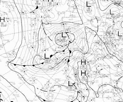
Below are the 500mb and surface analysis maps from 3 am yesterday morning (December 6), courtesy of Environment Canada. MSLP of 958 mb was reported on Sunday afternoon on St. Lawrence Island (at both Gambell and Savoonga), and that appears to be close to the all-time record for the area (about 955 mb according to 1950-present ERA5 data).


No comments:
Post a Comment