
Here's an illustration of how unusual the December precipitation was at @DenaliNPS HQ. This shows the percent of number of months in early winter with total precipitation grouped by half inch increments. Dec 2021 really is in a class by itself. #akwx @Climatologist49 @FDNMkris pic.twitter.com/IRyavUGmP6
— Rick Thoman (@AlaskaWx) January 7, 2022
From ERA5 reanalysis courtesy @CopernicusECMWF, percent of December precip that fell as snow (left) vs 1991-2020 average (right). Much lower percentages than average central/western mainland, but much higher percent of total precip was snow in Southeast. #akwx @Climatologist49 pic.twitter.com/RQBOpLZRuB
— Rick Thoman (@AlaskaWx) January 9, 2022
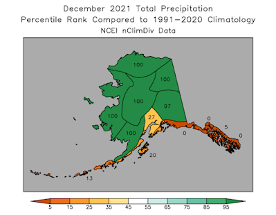
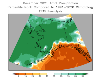
December precipitation was far above normal over much of Alaska & nearby areas in the Yukon & Chukotka — dramatic contrast to the Gulf of Alaska coast/Panhandle. Patterns like this result from unusual patterns aloft, here North Pacific record high pressure. #akwx @Climatologist49 pic.twitter.com/pCY3jF0jJS
— Rick Thoman (@AlaskaWx) January 8, 2022
Total rain/freezing rain (as opposed to precipitation that fell as snow) Dec 25-28, 2021 as seen in ERA5 courtesy @CopernicusECMWF. Huge area with high-end rainfall and close to unprecedented mid-winter amounts from Fairbanks southwest into @DenaliNPS. #akwx @Climatologist49 pic.twitter.com/81L46P7RKy
— Rick Thoman (@AlaskaWx) January 8, 2022
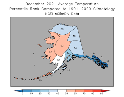
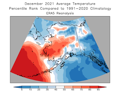
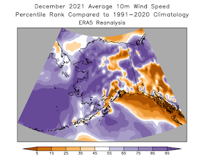
December was a wild, wacky and impactful #winter month weather-wise over much of Alaska. From unusual cold to unprecedented warmth, excessive snowfall to record dry. Plus severe blizzards, crippling freezing rain and damaging winds. #akwx #Arctic #akclimatehighlights @IARC_Alaska pic.twitter.com/Vz5ydMNVn7
— Rick Thoman (@AlaskaWx) January 1, 2022
No comments:
Post a Comment