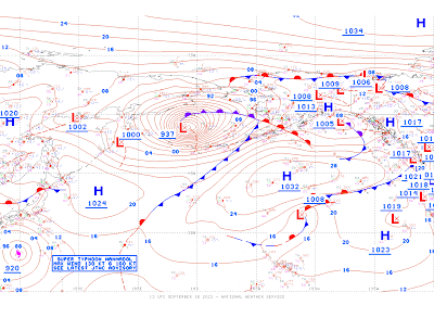
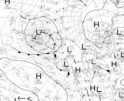
Today's (and tomorrow's) Bering Sea storm is a very big deal, and there will be more to say about it as reports roll in from hard-hit west coast communities. NOAA's Ocean Prediction Center analyzed the storm at a remarkable 937mb this morning, and the Canadians had it at 944mb. Either way, it's incredibly strong for the time of year, and it may be the lowest MSLP for any time of year at its location (1950-present). We'll see what ERA5 reanalysis has to say in a few day's time.
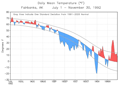
Thirty years ago, another major weather anomaly was affecting Alaska: extreme early-season cold. The September 1992 cold outbreak was outstandingly anomalous, and I'll have more to say about this too in the coming days. For now, here's a chart of Fairbanks daily mean temperatures compared to the modern normal.
By this point in the month (the 16th), Fairbanks was only a week into the extreme cold anomalies that lasted until early October. There were 10 inches of snow on the ground, and the low temperature was 12°F on the morning of the 16th (and +4°F in North Pole). Essentially, winter had arrived, because the weekly average temperature did not reach 32°F again until spring.
The scene is entirely different today. Here are a couple of glorious Twitter photos that caught my eye in the past few week - one from the Chena River State Recreation Area, and the other from our friend Brian Brettschneider near Anchorage. Spectacular!
Trail running in Interior Alaska during Fall is pretty friggin amazing! pic.twitter.com/4EgVywbDIe
— Chris Butcher (@AKtrailrunner) September 12, 2022
All the colors. pic.twitter.com/xp0yaYnL5t
— Brian Brettschneider (@Climatologist49) September 10, 2022


No comments:
Post a Comment