Last month I penned a few comments on the timing of the typical late summer transition to cloudier and wetter weather in Fairbanks. Traditionally this change is simply known as "August", but it's possible that the timing has shifted over the decades. I'm particularly interested in the hypothesis that the transition may be occurring earlier now, although I don't have a potential explanation in mind.
I showed this chart in the previous post, and it does send a compelling message that peak rainfall has shifted earlier over time:
However, this only addresses rainfall amounts, which we know have increased dramatically in July in the heaviest rain events (see here). What about the frequency of wet days? The chart below focuses on frequency: the top lines are for days with 0.05" or more of liquid-equivalent precipitation, and the bottom curves are for 0.25" or more.
Here we see that there hasn't been much change in the timing of the key transitions over the course of the summer: the frequency of 0.05" events has always peaked in the first half of August, and as expected the heavier 0.25" events peak a little earlier.
The most striking aspect of the frequency chart, at least during summer, is the increase in frequency for 0.25" events all the way through summer, and especially in the last 15 years. In late July and early August the frequency of these significant rain days has been well over 10% in the last 15 years, whereas it was well under 10% prior to 1990.
It's possible that the increase in frequency of significant rainfall events may partly explain the perception that August weather is arriving earlier these days, because early July now sees the same frequency of major rain events as the August peak used to bring. But note that this isn't true for lighter rain events, which have changed relatively little over time.
Another angle from which to explore the timing of seasonal changes is to look at upper-level winds. Fundamentally it is the strengthening of the jet stream that brings cloudier, wetter weather to northern latitudes in late summer, so it makes sense to see if any obvious changes have occurred over the decades. For example, has the mid-atmospheric westerly flow been gaining strength earlier in summer recently?
In the case of Fairbanks, the answer seems to be no - see below. Compared to 1961-1990, recent decades have actually seen weaker 500mb westerlies from mid-June through mid-July, although by late July the westerly flow has recovered to the same strength as before.
Below is the chart for Nome, which also shows a more extended window of low westerly flow in the past 30 years, but followed by a sharp increase into August.
Note that the mean 500mb wind actually has an easterly component from the central Bering Sea to southern Alaska in June, because of the tendency for a trough over the southern Bering Sea. It is the reestablishment of a westerly regime that brings the late summer change in weather patterns.
Here's a map of the change in westerly wind speed from June to August; the biggest increase anywhere in the hemisphere is over Bristol Bay.
The equivalent map for 1961-1990 is similar but does show some differences, most notably over the North Atlantic.
The change in the June->August wind difference (see below) shows that recent decades have seen a greater seasonal wind increase over southern Alaska and in many other locations at similar latitude around the hemisphere.
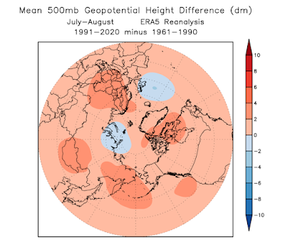
Interestingly, July-August average westerly winds have increased over all of northern Russia and across the Bering Sea to southern and southeastern Alaska. More work would be needed to dig into the cause of this, but it seems this is related to a relatively strong late summer polar vortex combined with increased ridging (higher geopotential heights) in mid-latitude and sub-Arctic regions (i.e. a stronger pressure gradient).
The 500mb wind speed chart for St. Paul Island confirms the change to stronger westerlies in July and August, and here we might make a case that indeed the seasonal recovery of westerlies has been occurring earlier in recent years.
With a mixed bag of results, I think the safest thing to say in conclusion is that more investigation is required. I'm intrigued by the idea that a strengthening north-south pressure gradient across the sub-Arctic in late summer may be generating an earlier recovery of the jet stream, leading to more unsettled weather at an earlier date than used to occur; I'll have to come back to this when time permits.


As a resident of Fairbanks I observe two general types of rain events...one caused by daily cloud buildups in unstable air followed by localized rain, the other tends to be longer and more area wide. Which of the two has contributed to this climate progression?
ReplyDeleteThe hypothesis is that the latter (longer, area-wide), which is more characteristic of August, has become more common in July. However, it may be that the observed increase in rain amounts - and frequency of heavier events - involves a change in both flavors. Good question and I now have an idea for a new avenue of investigation. Thanks.
DeleteI meant to ask which of those two contributes "more" to the progression. Depending on where you are, and where the sensing equipment is located, that affects the observed or measured precipitation. Typically for Fairbanks local precipitation initially forms then occurs over terrain surrounding town more often than directly over the city. It can of course move over the recording equipment. In contrast area wide precipitation just rolls in primarily from the SW or S and blankets us for a more lengthy period. And again the hills probably get more from lifting effect or stalling of the roll-in.
Delete