Here's a puzzle for readers, concerning events on the middle Tanana River right now. In what would be a very unusual event for the time of year, the Tanana River appears to have developed an ice jam yesterday near Fairbanks, causing the river gauge to register a rise of over 6 feet from yesterday morning to yesterday afternoon. The water has been dropping only very gradually today.

The odd behavior is confirmed by this report via Twitter:
Two days ago, the Tanana was dry and frozen. Went out there today and found this. So high that water was backing up the slough and flowing the wrong way. What the what??? pic.twitter.com/VwBqbzkgWM
— Boooooookish 👻📚(& Nerdish) (@AKLibraryChick) October 28, 2022
Water "flowing the wrong way" certainly suggests a jam.
My understanding is that it's very rare to see a genuine ice jam on a large river like the Tanana at freeze-up, because the ice is thin and easily dislodged; it's a totally different situation from spring ice jams. However, with ice developing and increasing during freeze-up, a jam that develops at this time of year can be very persistent and even cause chronic flooding throughout the winter. This may be a long-lived story.
Having said all that, though, there's a puzzle here: the Salcha River apparently had a very similar rise about 36 hours earlier. If a single ice jam were the problem, and water were backing up, the rise would have occurred much later at the Salcha gauge, which is about 40 miles upstream from the Fairbanks gauge. The Salcha-Fairbanks sequence looks more like a big volume of water is making its way downstream, although of course there may be more than one jam.
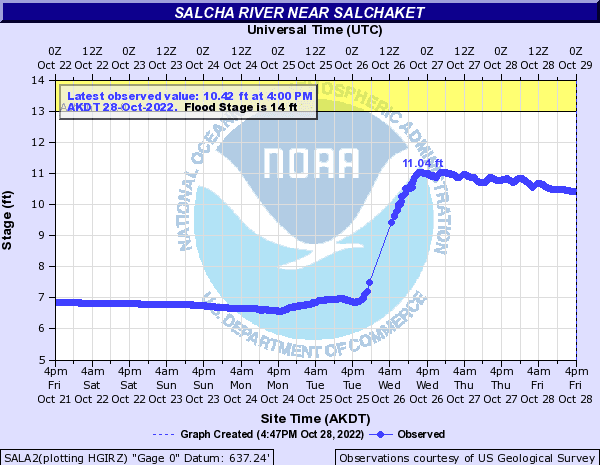
So which is it, ice jamming or a big new volume of water? We should find out more sometime tonight, when we would expect a downstream-propagating rise to reach Nenana (another 40 miles downstream). So far Nenana has seen a drop that aligns rather well with the rise upstream at Fairbanks, so this looks more consistent with the ice jam hypothesis (water held back and volume decreasing at Nenana).

I wonder if reader Gary wants to take a peek from his aircraft? (Only joking, I imagine the NWS will bear that expense and solve the puzzle soon.)
Here's the evening scene at Nenana:

Update Saturday morning:
No rise overnight at Nenana, and a new observation: the Kuskokwim River at McGrath also saw a sudden and significant rise early yesterday. It seems that ice jams are occurring widely during freeze-up this year. But why? Does anyone recall this happening in any previous year?

Update Sunday evening: another sudden rise, this one on the Koyukuk River at Hughes:

And another on the upper Susitna River. Clearly this is what freeze-up looks like for interior Alaska this year.

My plane's parked waiting some parts so am unable to look. It's been a relatively warm Fall with abundant rain/snow to the SE of Fairbanks - near the Delta Jct and Tok area. Some of that upstream precipitation may have entered the Tanana River's course and feeder streams. The local airplane float plane pond finally froze over Oct. 28th. Typically it's 10-14 days earlier in the month. The ground water table there is still fairly high and likely warm. If the aggregated ice freezes in place over shallow or restricted channels then water backup in the Tanana may continue. Years ago the military would practice by bombing ice jams...unlikely today tho.
ReplyDeleteEvents like this beg for the use of an unmanned aerial vehicle or UAV. Deploy them to observe and report. They are locally available and I bet the University has access to them.
DeleteThanks for the report, Gary. Yes, this seems like a perfect application for drone technology within range from deployment locations. Visible-band satellite can help too - I believe APRFC uses satellite for spring break-up monitoring.
Delete