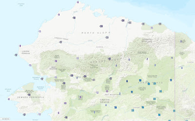
Winter is lingering in northwestern Alaska and the North Slope, where a cold air mass has been reinforced in the past couple of days by an upper-level low developing just to the north of Alaska. Temperatures were in the teens and 20s below zero Fahrenheit this morning across a wide area, and the wind chill dropped to near 50 below at Deadhorse (for example). Pretty chilly for a location with nearly 15 hours of daylight.
Here are minimum temperatures since midnight:
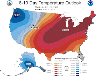
It's interesting to see a notable cold signal for much of Alaska in the CPC's latest 6-10 and 8-14 day outlooks:
I'll be curious to see if Alaska can manage a cold April overall, because I've long held a hypothesis that a disruption to the stratospheric "polar vortex" in January or February can sometimes (not always) produce a cold pattern for Alaska at this time of year.
The spectacularly cold spring of 2013 is the poster child for this idea: there was a major "sudden stratospheric warming" (SSW) in early January, and the effects definitely lingered for months in the boreal high-latitude circulation. 2006 and 2009 were also notably cold for Alaska in March-April, following January stratospheric warming events. More recently, 2021 was cold, but less so, and 2018 and 2019 were warmer than normal, especially in March; all of these years had SSW events.
We had a major SSW this winter on February 16, so let's see how the next few weeks play out. Late breakup, anyone? There are still a few hours left today to make a guess on breakup at Nenana...


Every day this continues the dice are being loaded a bit more towards significant flooding at breakup. Lots of snow in the Yukon and Kuskokwim basins this year.
ReplyDelete