

According to the NCEI climate division data, the North Slope saw its 2nd warmest November since 1925, with only 1979 having been slightly warmer.
Model-estimated and (sparsely-observed) grouth-truth measurements of precipitation are broadly in agreement that the month was generally wetter than normal except near the West Coast and in southwestern Alaska. Anchorage saw an amazing snow onslaught in the middle of the month that led to a new record for November snowfall (39.3") and liquid-equivalent precipitation (3.44").


Rick Thoman's post over at Substack provides much more detail:

It's interesting to look at what happened in past winters that had a very mild November in Alaska. Here's the December-February temperature analysis for the top 8 such years since 1950:

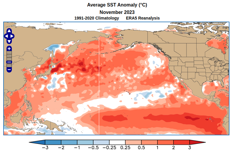
The big warm patch in the central tropical Pacific signals the presence of El Niño, which lines up with current conditions: we are currently in a robust El Niño - see the large and pronounced equatorial warm tongue in the November SST map above. A warm November is more often than not followed by a warmer than average winter in interior and eastern Alaska, which is also consistent with the typical El Niño outcome. The small sample of warm Novembers also suggests that below-normal temperatures may be slightly favored for Alaska's West Coast, but I wouldn't take that seriously with so much warmth in the North Pacific and Bering Sea this year.
Here's the average 500mb height (pressure) anomaly in the 8 years with very warm Novembers. This indicates a trough with low pressure near southwestern Alaska, a very typical setup for El Niño.

In light of this, today's forecast for the days leading up to Christmas is absolutely classic: the GEFS ensemble mean shows a powerful trough over the Aleutians and a very intense North Pacific jet stream - see below. It's rare to see ensemble-mean signals this strong nearly two weeks ahead of time, and as long as El Niño has this kind of grip on the pattern, it will be tough to get sustained or significant cold in Alaska.


We in Interior (well some of we) are enjoying this winter's warmth and lack of snow (dog musher's lament). Every so often WE get a reprieve from the bitter cold. The darkness is still here, the Christmas shoppers abound, and the heating/electrical bills are reduced. Not bad at all so far.
ReplyDeleteWell considering I do maintenance on the village distribution piping, a warm winter means less jetting. However thawing permafrost means more settling. Pick your poison I suppose.
ReplyDeleteMike