Tuesday, December 31, 2024

Snowpack

Happy New Year to all.  Let's check in on Alaska's snowpack at the turn of the year.  It's a mixed bag, but generally snowfall has been much less abundant than in the Fairbanks area (relative to normal), according to ERA5 estimates:


Fairbanks has 22" of snow on the ground, according to the official measurement, and that's towards the upper end of the historical range for the time of year - although there was much more (34") on New Year's Eve in 2021.  The SNOTEL sites in the hills above Fairbanks are reporting about 150-200% of normal snow water equivalent, and the Mt Ryan site (2800' elevation) has been at record high snowpack since late October (only recently dropping behind the 2021 trajectory):


In contrast, there is a real dearth of snow across the Seward Peninsula and across nearly all of southwestern and south-central Alaska.  We have to go back to 2016 to find so little snow in late December for southwestern Alaska; but in that case the shortfall was much greater statewide:


Anchorage has 8" of snow on the ground, a lot less than the last two years, and the least since 2019 on New Year's Eve.  A number of SNOTEL sites around South-Central are reporting well under 50% of normal SWE - see below.  Let's hope this situation doesn't worsen in the weeks and months ahead.


Thursday, December 26, 2024

Howard Pass Again

It's time for another mention of northern Alaska's "pole of cold" for measured wind chill, i.e. Howard Pass.  As noted by reader Gary, conditions have been harsh up there in recent days.  In typical fashion, strong northerly winds funneled cold air through the pass (elevation near 2000 feet) with great ferocity starting last Saturday evening, and it wasn't until yesterday afternoon that the wind chill rose above -60°F for the first time in over 3 days.


The minimum wind chill based on hourly mean temperature and wind speed was -73°F on Sunday evening (-25°F temperature, 80mph wind).  This is respectable but not all that unusual for the location; wind chills this cold or colder are observed at least once in nearly every winter.

The MSLP analysis from Environment Canada shows the very typical setup at 4pm Sunday, with a very tight pressure gradient caused by a ridge to the north and sprawling low pressure across southern Alaska.


In the 2012-present history of the NPS instruments at Howard Pass, -60°F wind chill has been observed as early as November 17 (2021) and as late as April 9 (2013).  As one might expect, it's most common in January and February.  Interestingly, this is the first time the wind chill has stayed below -60°F continuously for more than 80 hours this early in the season.  However, late November 2021 saw a much more prolonged period of substantial cold, with 11 straight days having a wind chill reading below -60°F at some point in the day.

Friday, December 20, 2024

Autumn Climate Data

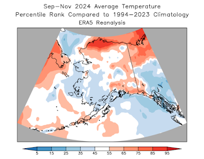
Autumn seems like a long time ago for much of Alaska, but it's worth making a mention of the autumn climate anomalies, if only for future reference.  I'll use "autumn" here to refer to the standard climatological season of September through November.

Statewide all three months were slightly warmer than the 1991-2020 average, and the North Slope was considerably warmer than the 30-year baseline, but overall it was a slightly cooler autumn than the last two years (but nowhere near as cold as 2021, when November was very cold).  The North Slope was the only region with a large departure from normal temperature, although parts of Southeast were relatively cool according to the consensus of ERA5 and NCEI data:


More significantly perhaps, September through November was the driest such period in Alaska since 2016, according to NCEI, and nearly all western and southern coastal areas encountered this dryness.  All three months were drier than average on a statewide basis, and that's the first string of three consecutive dry months (relative to normal) since spring 2022.  And yet in contrast, the central interior was very wet, with Fairbanks observing its wettest autumn since 2017; only five autumns have been wetter since 1930.  The wet weather occurred mostly in October.


November was easily the driest month of the autumn, as the Aleutian ridge of October shifted north and took up a dominant position over the Bering Sea and western Alaska - see below.


With Pacific storms held at bay, winds were lighter than normal for most of western Alaska in November, and autumn wind overall wasn't dramatically different from normal for most of the state.  That's a big difference from summer, which was exceptionally windy in the western half of the state.


The calm weather in the Bering Sea allowed SSTs to return to near-normal there, eliminating the cool anomaly that developed back in the summer.  However, exceptional and widespread warmth persisted to the south of the Aleutians, and the Gulf of Alaska remained quite cool throughout autumn.


As a reflection of the extreme temperature anomaly differences across the North Pacific, the PDO index became extremely negative throughout the autumn.  Before the past decade or so of exceptional warmth in the North Pacific and in the Arctic, it was commonly observed that (at least southern) Alaska had a strong tendency for unusual cold during pronounced negative PDO episodes, but we don't see the same robust connection these days.  Consider the map below, showing the average temperature departure from trend in 10 past years with a significantly negative PDO index in autumn:


Compare this to the temperature anomaly map for autumn 2024:


The general orientation of the anomaly patterns is approximately the same, but the 2024 map is considerably warmer overall.  I think this illustrates that even with a favorable SST configuration, cold in Alaska these days tends to be very muted by historical standards.

Tuesday, December 17, 2024

No More Wind Chill Warnings

On Friday the National Weather Service in Fairbanks issued an "Extreme Cold Warning" for two eastern interior forecast zones: the Fortymile country and the White Mountains.  This warning has rarely, if ever, been issued by the NWS in Alaska, so one might think conditions must have been extreme indeed.

But no: in a recent change of procedure, the Extreme Cold Warning simply replaces the old Wind Chill Warning for the NWS nationwide.  The goal is to simplify communication of weather hazards:

"Social science research indicates users of NWS products can become confused by the number of hazard messages NWS issues before and during active weather. Especially while dangerous weather is unfolding, it is critical that NWS hazard messages are simple, short and direct."


So how cold did it get over the weekend?  Well, it was certainly very chilly, with temperatures dropping below -40° in the usual cold spots of the eastern interior, and wind chills of -50°F in some places.  The lowest wind chill measurement I saw was -52°F at Delta Junction early on Sunday morning.  Here's a map of observed wind chill in the region surrounding Fairbanks at about that time (click to enlarge):


The following chart shows the 850mb (approx 5000 feet elevation) temperature and wind at 10pm Saturday.  As is often the case, the cold air mass arrived from the northeast as it traveled clockwise around a high pressure ridge to the north.  (The blank areas on the map are locations where the surface pressure is less than 850mb in the model.)


Tuesday, December 10, 2024

Alaska's Changing Environment

Last week UAF released an updated version of their summary report on "Alaska's Changing Environment", documenting trends and recent events across many aspects of the natural environment in Alaska.  I recommend taking a look at the latest report, which updates and extends the original 2019 publication:

https://uaf-accap.org/alaskas-changing-environment/

There's a wealth of information in the document.  Extreme events of recent years are highlighted (e.g. ex-Typhoon Merbok, landslides), and the discussion goes far beyond traditional weather and climate metrics to explore ocean and wildlife changes that I knew nothing about.

Coming back to today's weather, my late November comment about the negative PDO phase favoring colder weather in southern Alaska is being challenged in dramatic fashion, as western and southern regions have been overwhelmed by warm Pacific air in the last couple of days.  Anchorage reached 47°F last night, the highest December temperature since 2019, when it reached 51°F (the monthly record).  Nearby Merrill Field and Elmendorf AFB both reached 51°F last night, and again that's the warmest since 2019.  It was even warmer a bit farther north:


There'll be no prizes for guessing the Pacific weather pattern responsible for this: widespread low pressure across the Bering Sea and Aleution region, and a prominent ridge over western Canada.  Here are maps from 3pm AKST yesterday:


Tuesday, December 3, 2024

Haines Ice Storm

A major winter storm has affected Southeast Alaska in the last few days, with very heavy rain in the south, well over a foot of snow in Juneau, and freezing rain in the northern Panhandle yesterday and today.

Juneau saw six hours of freezing rain yesterday morning, with the ASOS instrumentation suggesting that ice accretion may have reached 0.2", and then Haines suffered significant icing today.  Hourly data from Haines shows freezing rain for about seven hours, and the ASOS algorithm indicated ice accretion of 0.3".  The National Weather Service relayed reports of as much as 0.5" of ice, and they issued an Ice Storm Warning - apparently the first ever to be issued by the Juneau NWS office.

Freezing rain isn't particularly unusual for communities in the northern Southeast, of course, because the ingredients are quite easy to come by: cold low-level air drawn from the frigid interior, and warm air aloft from the Pacific.  Haines ASOS data since 1996 indicates that freezing rain is reported at least once in just about every winter, and it's not uncommon to have a half-dozen days or more with freezing rain: for example, the winters of 2018-19, 2022-23, and 2023-24.

However, the data also suggests freezing rain isn't typically prolonged in Haines, as warm Pacific air usually wins out rather quickly.  The hourly Haines data indicates that the record for consecutive hours with freezing rain is 9 hours - only a little more than today's event - and that occurred in December 2019.  The NWS discussion highlighted the unusual nature of the current storm: "In fact, more freezing rain has been observed during this one event than some of the staff here at the office have seen over the past 18 years."

As is typically the case, the freezing rain eventually changed to plain rain for both Juneau and Haines, as temperatures rose above freezing.  This is the normal course of events, as warm air typically erodes and displaces the surface-based cold air, at least in a coastal setting like Southeast Alaska.  Here's the NWS graphic for how precipitation type depends on the vertical temperature profile:


Monday, December 2, 2024

Dawson Follow-Up

Following up on last week's post about Yukon River freeze-up at Dawson City (Yukon Territory), it's worth looking at whether excessive warm season precipitation may have been a factor in preventing a complete freeze-up in some recent years.  To recap, the Yukon failed to freeze over properly at Dawson in the winters of 2016-17 though 2018-19, and then again last winter; but freeze-up did succeed in 2019-20 through 2022-23, and again this winter.

Here are the May-September precipitation estimates from ERA5 for the months prior to the "no freeze" winters:


There's no evidence here that the southern half of the Yukon Territory (much of which is in the Yukon drainage) was consistently wetter than normal in these years, and in fact the summer of 2023 was somewhat dry.

As for recent "normal freeze" years, 2019 was dry, but others years tended to be more on the wet side; and this summer wasn't particularly unusual in either direction.


How about water levels at Dawson?  Here are the September mean water levels in the no-freeze years, for the Yukon River (left) and the tributary Klondike River (right), which meets the Yukon immediately upstream of downtown Dawson:

2016   2.02m   1.36m

2017   1.56m   1.23m

2018   1.85m   1.10m

2023   1.60m   1.30m

And the normal freeze-up years:

2019   1.03m   0.85m

2020   2.65m   1.39m

2021   2.30m   1.28m

2022   2.16m   1.65m

2024   2.12m   1.50m

With the exception of 2019, the normal freeze-up years all had higher Yukon River levels in September than the no-freeze years.  The tendency is the same for the Klondike River, with 2022 and 2024 both having higher levels than the no-freeze 2023.

I think we can therefore dispense with the idea that the freeze-up failures occurred because of higher flows - if anything, the reverse seems to be more likely - but I won't indulge in any more speculation now.  Previous posts and discussions in the blog comments can be accessed by searching the blog archives for "Dawson".


Wednesday, November 27, 2024

Frozen Over at Dawson

A couple of interesting items came to my attention today.  First, the Yukon appears to be properly frozen over at Dawson City in the Yukon:


This is big news over there, because the lack of freeze-up next to town has been a huge problem in recent years; freeze-up has often been much delayed and sometimes hasn't occurred all winter.  I've commented on it occasionally, most recently last March:


The change this year isn't caused by colder weather - it hasn't been unusually cold - and the lack of freeze-up in recent years was generally not caused by unusual warmth.  When I have a chance, it will be worth looking at regional streamflow and precipitation data from recent months to see if anything stands out.

Here's an animation of webcam images from today, courtesy of http://dawson.meteomac.com/


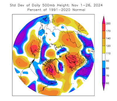
On a completely different note, I ran some calculations today to establish whether the Northern Hemisphere circulation patterns have been unusually volatile this month; it sure seems like it.  The answer is yes: the following chart shows a metric of 500mb volatility for 45-90°N around the globe.


To be precise, the figure shows the area-average of the standard deviation of 500mb heights for November 1-26, expressed as a fraction of the 1991-2020 normal (which differs from place to place).  Here's a map of the departure from normal: 500mb heights have been much more variable than normal over the eastern Bering Sea and southwestern Alaska, as well as near Baffin Island and over northern Europe.


The region of high variance near Alaska largely reflects the dramatic change from this a few weeks ago:

to this last week:


The big ridge over the eastern Aleutians and southwestern Alaska about a week ago was bumping up against records for the month of November.

What could explain the volatile patterns around the higher latitudes of the Northern Hemisphere?  I think it's the unusual combination of sea surface temperature anomalies across the tropics and the mid-latitude oceans.  We have a weak La Niña, which tends to favor meandering "blocking" patterns in the high latitudes in early winter (November in particular), but we also have tremendous warmth in the northwestern North Pacific, which favors mid-latitude ridging (high pressure) and a stronger, more west-east jet stream to the north of the ridge.  These two Pacific ocean anomalies therefore currently have opposing influences on the jet stream pattern, as I see it, and volatility has resulted.

Looking ahead, as winter settles in, La Niña's influence will very much shift towards favoring a stronger jet stream with a strong polar vortex, and that in turn will tend to favor unusual cold in Alaska, particularly in the south.  This is very consistent, of course, with a negative PDO phase, which is locked in because of the warmth to the east of Japan.  Here's the SST anomaly from the past month:


In conclusion - bundle up; and happy Thanksgiving to U.S. readers.

Friday, November 22, 2024

High Wind History

After mentioning strong winds in Wednesday's post, I thought it would be interesting to look at the top high wind events of recent decades - at least according to ERA5 reanalysis data.  I did something similar for the lower 48 the other day, showing that September's Hurricane Helene ranked #5 for area of the contiguous U.S. that experienced hurricane force wind gusts.  What are the top events in Alaska's modern history?

The ERA5 data goes back to 1940, although pre-1950 the uncertainty is very high, so we won't look at anything quite that far back.  The event with the greatest land area coverage of hurricane force wind gusts (64 knots or higher), based on peak wind speed in a 3-day window, was in early 2000:


This event pops up in the Deep Cold archives, finding a mention as the date with the highest sustained wind speed (58 mph) at Delta Junction airport in the 1998-present ASOS era.

Second on the list since 1950 is a North Slope wind storm at the end of 1951.  Hourly observations from UtqiaÄ¡vik confirm a peak sustained wind speed of 56 mph (gusts not reported).


Number 3 was in February 1989: the North Slope again.  Gusts were measured to 60 knots (69 mph) at UtqiaÄ¡vik.


And in fourth place, a more recent event that brought damage and power outages to the Anchorage area:


Events #5-#8 highlight southern and especially southwestern Alaska as a hot spot for these widespread strong wind events - as we might expect with the favored Aleutian storm track.


I'm a little surprised not to see a west coast event in this list; even ex-typhoon Merbok doesn't rank anywhere near the top:


Wednesday, November 20, 2024

Active Weather

The weather pattern has been very energetic and changeable across Alaska in recent days, leading to sharp cold in some areas, and wind and storm damage in others.

Coastal erosion and damage occurred down in Homer over the weekend, and far to the northwest Point Hope is without power today, owing to high wind.  Winds gusted to 68mph in Point Hope yesterday, and 93mph at nearby Cape Lisburne.  Today the high winds spread across the North Slope, with UtqiaÄ¡vik gusting to 62mph and temperatures rising above freezing.

Here's this morning's 3am MSLP analysis, courtesy of Environment Canada:


Several things can be noted here: the axis of high pressure across the southern interior, associated with cold weather at the surface; the strong pressure gradient across northwestern Alaska, producing the high winds; and the extraordinarily deep low pressure system to the west of Seattle, causing severe wind damage in Washington last night.

The cold yesterday morning was notable across the interior: -40° was reached on the Yukon Flats at Beaver, and Chicken saw -42°F.  Fairbanks reached -29°F at the airport, the coldest this early since 2020 - and we have to look back to 2011 to find colder conditions this early in the season.  The Salcha RAWS reached -37°F, the coldest this early since 2011.