https://ak-wx.blogspot.com/2023/11/a-few-notes.html
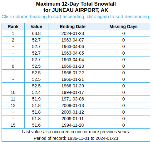
Juneau has now countered with a yet more extreme snow situation, with two huge storms in the space of 10 days, and a 12-day total of 64". This is the greatest snow accumulation on record for windows of 11-18 days, and it's well ahead of the previous record for 12-day snowfall:
The latest 3-day total of 34.5" at Juneau airport is itself the 3rd greatest on record, exceeded only by storms in 1963 and 1966. Even higher amounts were reported from other locations, including 48" around the corner on Taku Inlet.
According to the NWS, "Juneau Docks and Harbors Department reported several boats capsized or sunk by weight of the snow".
The key aspect of the weather setup seems to have been a near-stationary frontal zone draped across Southeast Alaska: below are the surface analysis charts from 3pm Sunday, Monday, and Tuesday respectively. Notice the long stationary front marked on the top image and resurrected on the last image, with broad areas of low pressure over the Gulf and modest high pressure to the east and north.


A slow-moving weather situation is obviously a prerequisite for prolonged periods of heavy precipitation. It also seems clear that the relatively weak nature of the Gulf low pressure was a key factor, because the warm southerly flow wasn't strong enough to drive out low-level cold air, and precipitation remained in the form of snow longer than expected. A stronger, more dynamic Gulf storm would have quickly swept warm air into the Panhandle and produced rain instead.
From the NWS Juneau discussion on Tuesday afternoon:
Southeast Alaska Forecast Discussion
National Weather Service Juneau AK
332 PM AKST Tue Jan 23 2024
.SHORT TERM...Winter weather continues for places north of the
Icy strait corridor while places to the south continue to see
rain. Temperatures this afternoon have been slow to warm up,
especially those still under the influence of outflow winds. Model
guidance continues to try and warm up locations that are
currently seeing snow but observations continue to show cold air
remains. A wave moving up from the south has started to enter the
panhandle bringing a reinforcing shot of moisture to the area.
This wave could also bring a surge of warm up form the south to
the north as well. The big question with this remains are the
winds associated with it strong enough to mix out the surface
inversion that has allowed us to see snow. Current thinking is
that we will see a slight warm up with this wave but that it will
not be strong enough to mix out the cold air. With that being the
case, the Juneau area is expected to continue to see snow. If the
wave does succeed in mixing out the surface inversion, the snow
will switch over to rain fairly quickly. The current forecast
tried to reflect this possibility of staying snow for longer and
the winds failing to mix out the inversion until tomorrow.
No comments:
Post a Comment