First, here are some charts showing the number of hours each winter with freezing rain reported by the airport ASOS instruments in Haines, nearby Skagway, Juneau, and also Yakutat (not in the same climate zone but not too far away). The two winters before this one (2022-23 and 2023-24) both brought a lot of freezing rain to Haines, and 2021-22 saw far above normal freezing rain in Juneau, but unfortunately the data is missing for Haines for most of that winter.
At Yakutat, the data shows a sustained higher frequency of freezing rain since 2016-17; but interestingly this winter is not following suit, with only a couple of brief instances (not included on the chart).
If we average the data from these 4 sites together (using the annual departure from normal at each site), we get an interesting result that does suggest an uptick in frequency since 2021-22.
Does this have any support from the ERA5 reanalysis data? There is a modest correlation between ERA5 and "ground truth" data for Haines, but surprisingly ERA5 does not show any increase in the last couple of years:
A map view of the ERA5 data confirms no widespread increase in freezing rain across the northern Panhandle region, although an increase shows up in a few places for 2023-24. Of course the region has extremely complex topography and we would expect huge variations in local conditions; there's no doubt the ~30 km grid spacing of ERA5 is far too coarse to handle this properly, but nevertheless it apparently does have some modest ability to reproduce conditions in Haines, at least prior to 2022.
Here's the average since 2013-14, the beginning of the recent sustained warmth in the North Pacific and Alaska region:
There's no signal for the northern Southeast, so it is difficult to draw a firm conclusion as to whether freezing rain is increasing there or not.
Of course it's a different matter in the southwestern interior, Y-K Delta region, and the northern Bristol Bay coast, where freezing rain has certainly increased in recent years. Here's a chart of observed frequency from Bethel:
And a longer-term view, bearing in mind that pre-1998 data comes from manual observations, not ASOS, and so there might be (probably is) a bias/discrepancy in how frequently freezing rain is reported.
See this previous post for additional results on winter rain and freezing rain in Alaska and the Arctic:
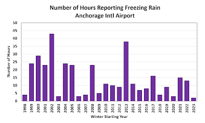
Finally, for good measure, here are charts for Anchorage and Fairbanks. Note that this is for freezing rain, not plain rain (such as occurred last month in many places).


No comments:
Post a Comment