A new study was published a couple of weeks ago, documenting the changes that have occurred in temperature, precipitation, snowfall, and sea ice around and across Alaska since 1957:
Alaska Terrestrial and Marine Climate Trends, 1957–2021
Rick Thoman, founder of this blog, is one of the co-authors.
The paper provides a nice summary of the main climatic changes over the 65-year period, and I recommend taking a look.
The two key data sources for the analysis are the ERA5 reanalysis and the NOAA/NCEI climate division data, the same two sources that I often use to look at monthly and seasonal anomalies. Both sources have their advantages and drawbacks. In principle, it's more appealing to use "ground truth" data from climate observing sites (the NCEI or "ACD" data), but in practice the scarcity and quality of Alaska's climate observations are so problematic that the ERA5 (modeled) data is sometimes preferable.
In terms of climate trends, one of the more eye-catching discrepancies between the two data sources is the disagreement regarding temperature trends for Southeast Alaska. Here's Figure 3 from the paper (click to enlarge):

Remarkably, ERA5 shows a 65-year temperature trend that's about 3 times the NCEI trend for the Panhandle climate divisions. The paper notes this discrepancy in passing, commenting "topographic complexity presents challenges for regional trend estimates", but no further investigation is performed. The authors seem to accept the ERA5 values as more realistic, as the article's abstract and conclusions cite the very large trends in the North Slope and North Panhandle regions.
I decided to look into this a bit more. The figure below illustrates the discrepancy for the North Panhandle climate division in particular.

The two data sets show a drastic difference in trend, and it's fairly consistent over time, i.e. not obviously caused by a few "bad" years in one of the sources.
Here's a look at the annual data from two key sites in Southeast Alaska: Sitka and Juneau - see below. The trends at these sites tend to support the NCEI (ACD) result, with much less warming than ERA5. In particular, the relatively warm years of the late 1950s and early 1960s are on par with the modern climate, whereas the ERA5 data shows much cooler conditions in the earliest years of this analysis period.

A map of the ERA5 trend gives a hint as to what might be going on.

Notice that ERA5's 2m temperature trend over the Gulf of Alaska is small - less than 0.2°C/decade generally, and around 0.1°C/decade near the Alaska Panhandle. But over the Panhandle itself, the trend is very high - locally in excess of 0.6-0.7°C/decade.
Given that the ERA5 resolution of 31km is far too coarse to resolve the complex topography of southeastern Alaska, the ERA5 temperature represents modeled averages over grid cells with a mean elevation well above sea level. In contrast, the NCEI trends are derived from climate observing sites, most or all of which are very near sea level. Therefore it's hardly fair to expect consistency between the two sources: ERA5 is most definitely not modeling conditions at sea level.
Digging a little deeper still, I pulled out the temperature trends for every ERA5 grid cell that has more than half of its area within the Panhandle climate divisions. The following chart illustrates the relationship between trend and grid cell elevation.

While the overall correlation is not particularly strong, the very lowest elevation grid cells have easily the smallest temperature trends, and all of the trends above +0.6°C/decade are found for grid cells at more than 400m elevation. This supports the idea that sea level sites in the Panhandle have not in fact experienced the drastic warming that the ERA5 data suggests at first glance.
Out of curiosity, I also calculated the ERA5 temperature trends in the "free atmosphere" at 925mb and 850mb, i.e. about 2500 and 4500 feet above sea level, depending on the time of year. (In locations where the land surface is above these pressure levels, the model fills in the data with an extrapolation as if the ground were not there, just for convenience/completeness.)


The temperature trends over Southeast Alaska are much smaller aloft, and there's also much less contrast between ocean and land, as we would expect. Evidently, then, ERA5's very large surface temperature trends in the complex terrain of Southeast Alaska (and nearby western Canada) are not just a reflection of high temperature trends in the free atmosphere aloft.
Finally, to confirm that nothing surprising is going on with the trends aloft, I used sounding data from Yakutat to look at the temperature difference between the surface and 850mb. There's a slight but insignificant upward trend:
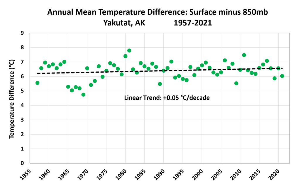
In conclusion, I think there's a serious question as to whether the long-term temperature trends are realistic in the ERA5 2m temperature data for Southeast Alaska. It is possible that there has been drastic warming at the higher elevations and that ERA5 is capturing that properly with its coarse grid cell averages, but the ERA5 2m temperature trends do not appear to correspond to either sea-level trends or free-atmosphere trends.
Next steps in this investigation might be:
- Look for long-term "ground truth" temperature data at relatively high elevation in Southeast Alaska; there might not be any.
- Examine the ERA5-Land data, which is a downscaled version of ERA5 at 9km resolution. This might have a better chance of reproducing trends in the complex terrain.
My experience is that adjacent ocean temperature and advection influences terrestrial climate. Clouds affect insolation and tend to moderate any solar input of heat. I'd look at ocean temps vs reported or estimated terrestrial temps for any trends at the surface. Few choose to live at elevation (and hence in clouds) in Southeast Alaska.
ReplyDeleteYes, and Southeast Alaska's climate has such a strong maritime influence that it's very hard to imagine low-elevation trends departing much from the (subdued) ocean temperature trends.
DeleteFive years in Sitka (sea temps except cold and clear from East winds from mainland in wnter) - one in Juneau (sea temps but cold with East wind from mainland and glaciers in winter), and two in Kodiak surrounded by ocean. All have convinced me any elevation effects on climate or daily temps are moderated by the ocean
DeleteAnother factor fo SE AK is the presence of extant vegetation. Forests and underlying duff - thick in old growth areas. Not much for a heat source there (they tend to trap moisture and reflect ambient sea temps) unless the Sun shines - rare. Warm advected air from (? - up/down/sideways) ) might cause a brief warming trend, but the ballast is the sea via prevailing winds.
Delete