While the topic is still fresh in my mind, I did some follow-up on Wednesday's question about whether the ERA5 temperature trends are realistic for Southeast Alaska. Specifically, I wanted to compare the ~9km resolution ERA5-Land data to the ~30km ERA5 reanalysis.
According to ECMWF, ERA5-Land "adds value to ERA5 surface fields and provides users with a more accurate dataset for surface applications. The impact can be particularly important over complex terrain, where accurate orography is very important."
This sounds promising for Southeast Alaska. Here's a visual comparison of the 1957-2021 linear trend in 2m temperature from the two sources: ERA5 on top (the data I looked at on Wednesday) and ERA5-Land below.
Clearly the ERA5-Land trend is smaller overall in this region, and it does not reach such high values in some of the areas of high terrain. Also, the ERA5-Land trend values are obviously much lower over the coastal islands of Southeast Alaska.
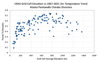
Here's the elevation versus trend analysis for all grid cells within the Panhandle climate divisions: ERA5 on top, ERA5-Land below.
The highest trends are significantly lower for ERA5-Land than for ERA5, and the lowest elevation grid cells have trends that are quite consistent with the results from the climate divisions (~0.16°C/decade) and from Sitka and Juneau (0.14 and 0.26°C/decade). Contrast this with the area-average ERA5 trends of 0.44-0.55°C/decade for the Panhandle climate divisions, as presented in the new paper by Ballinger et al.
In my view, these ERA5-Land results strengthen the argument that the coarse-resolution ERA5 data produces unrealistic trends for Southeast Alaska as a whole, and especially if we're interested in the low elevations where most people live. Given the obvious shortcoming of the coarse ERA5 data, and the likelihood that ERA5-Land still isn't quite right, I think we should accept the NCEI climate division trends as more representative of reality, especially for inhabited locations; and arguably then inhabited Southeast Alaska may have the smallest warming trend of anywhere in Alaska.
Here's a comparison of the ERA5 vs ERA5-Land linear trends for each climate division: the ERA5-Land trends are slightly higher for the west and interior, but much lower for the Northeast Gulf and Panhandle divisions.
| Division | ERA5 | ERA5-Land |
| North Slope | 0.55 | 0.55 |
| West Coast | 0.37 | 0.39 |
| Central Interior | 0.35 | 0.36 |
| Northeast Interior | 0.38 | 0.41 |
| Southeast Interior | 0.28 | 0.32 |
| Cook Inlet | 0.31 | 0.30 |
| Bristol Bay | 0.34 | 0.32 |
| Northwest Gulf | 0.26 | 0.25 |
| Northeast Gulf | 0.37 | 0.31 |
| North Panhandle | 0.55 | 0.41 |
| Central Panhandle | 0.49 | 0.32 |
| South Panhandle | 0.49 | 0.32 |
| Aleutians | 0.20 | 0.19 |
And finally, a statewide comparison in map form:


Yearly ocean and nearby land temperatures for Sitka are readily available. Historic ocean temps may have varied influencing terrestrial values.
ReplyDeleteHere's an elevated (716m/2349ft) station near Sitka. Not many others apparently.
https://dggs.alaska.gov/weatherstations/#5
Thanks Gary, that looks like good data, but with only a short history, apparently.
Delete