First a quick note on meltout at higher elevations around Fairbanks: the Munson Ridge SNOTEL site (3100' elevation) is still reporting 4.9" of water content in the snowpack early today (and a snow depth of 18" yesterday). With relatively warm weather, nearly 12" of snow water equivalent has melted out in the past 10 days, and the snowpack is no longer a record for the date: in 2000, there was still 7.8" of water on the ground on June 4. Since 1981, there have been 4 other years with snow remaining at this date: 1982, 1985, 1992, and 2000.
Down at Denali NP headquarters, the reported snow depth dropped to zero on Monday, which makes this the latest meltout on record for the venerable climate observing site:
After 100 years of snow measurements at @DenaliNPS headquarters in Alaska, winter 2021-2022 had the greatest snowfall total (174.4"), greatest snow depth (69" on Feb 20 this year), and now the latest snow meltout (May 30). [But incomplete data prior to 1950] https://t.co/BYv51MFmyz
— World Climate Service (@WorldClimateSvc) June 3, 2022
But onto another topic: the National Interagency Fire Center issued their wildland fire potential outlook on Wednesday. Large areas of the lower 48 are facing above-normal wildfire risk, but there is no departure from normal in the forecast for Alaska. For example:
The discussion does acknowledge unusual dryness in southwestern Alaska, and indeed this week's Drought Monitor has "moderate drought" in south-central (see below), but the ongoing La Niña episode is recognized as a negative factor for wildfire activity.
I've commented before on the strong relationship between Alaska wildfire acreage and ENSO (El Niño vs La Niña), but it's worth looking at this again with a few more years added to the analysis. The scatterplot of fire acreage versus June-July ENSO phase is quite remarkable:
I don't have fire data prior to 1990, but in the last 32 years, the top 9 fire years all had a positive ENSO phase (but marginally so in 1990), and the highest acreage with a negative ENSO phase was 1.3 million acres in 2013 (a hot summer, but dry with little lightning).
For reference, the April 2022 ENSO index was -1.6. The current La Niña episode is one of the strongest on record for the time of year, and it's very likely to persist through summer:
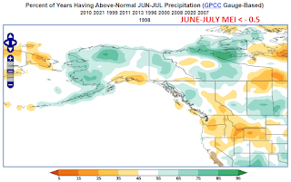
As for why La Niña tends to prevent excessive fire acreage in Alaska, it's clearly related to La Niña's influence on the prevailing weather pattern: it is often relatively cool, damp, and cloudy, especially in western Alaska. Here's a frequency analysis of the June-July weather anomalies in the 11 years since 1990 that saw La Niña conditions:
There tends to be an upper-level trough from western Alaska to British Columbia, and this is aligned with the negative PDO phase that tends to prevail in conjunction with La Niña (and indeed the PDO is quite strongly negative at present):
One other aspect: wind speeds tend to be lower than normal across the entire interior, which may help reduce fire growth.
In summary, the ongoing La Niña regime strongly favors a relatively inactive wildfire season this year in Alaska. However, I'd caution that it's not a certainty: one of these years there will be an exception to the rule, and even "relatively inactive" could still be problematic: there were 3 La Niña years with 1+ million acres burned. And of course, if the current warm and dry weather persists, there will definitely be problems.


No comments:
Post a Comment