Thursday, June 23, 2011

Active Lightning Day


Deep moisture streaming westward from the northern Yukon fueled the most active lightning day of the season thus far, with more than 4000 strikes. Virtually all the strikes were in the far northeastern Interior. There was a fair bit of rain with these storms, but some fire starts are very likely.

Monday, June 20, 2011

Retreating Sea Ice


Here is a NOAA-19 Polar Orbiter photo (from NWS Alaska Region) taken early Monday afternoon, with clear skies over much of Arctic Alaska. The ice edge is very well defined, with only a little shorefast ice on the coast and a few chucks in the open southern Chukchi Sea large enough to show up in this 1.6 km resolution image. There is also a little ice left in Kotzebue sound south of Cape Espenberg. Needless to say, this is much less ice than use to be normal for mid-June. According to the National Snow and Ice Data Center, the total ice cover as of June 19th across the entire Arctic is easily the lowest ever since satellite measurement of Arctic ice cover started in 1979.

Saturday, June 18, 2011

Soaking Rains Show Up in the Rivers


Here is a hydrograph of the level of the Chena River near the Wendell Street Bridge. The big rise late Thursday and Friday, more than three feet, is more than I would have expected, given that there wasn't that much rain. Even the Munson Ridge SnoTel, at 3100' MSL south of Chena Hot Springs got less than an inch of rain on Wednesday.

Friday, June 17, 2011

The Tall One


The mountain from Wonder Lake Rangers Station Friday morning.

In Lower Tanana Athabascam, Denaathi, in Koyukon Athabascan Denaali, "the tall one"

Thursday, June 16, 2011

Drought Breaker?


All of the Fairbanks area has received rain over the past several days, but amounts vary widely, as is usual for this time of year. The wettest areas have been on the east side of town: North Pole picked up 1.1 inches of rain Tuesday and Wednesday. Much less on the northwest side of town, including here on Keystone Ridge and on the Hastings Fire. Just 0.14 inches of rain here Tuesday and Wednesday. The Airport has had 0.20 inches. So while not a drought breaker, the rain definitely helps in the short term. In order to squash the fire season, we need frequent rains over a several week period. Drought

Here is a photo looking north from our house about 130am ADT Thursday. In spite of it being 44F, mosquitoes were still nasty.

Monday, June 13, 2011

Summer Snow


Snow this Monday morning in the Brooks Range. Here's a 718am photo from the FAA webcam at Anaktuvuk Pass. The snow has made it onto the south side of the crest, with 34F and (evidently) mixed rain and snow at Arctic Village.


Updated:


PUBLIC INFORMATION STATEMENT
NATIONAL WEATHER SERVICE FAIRBANKS AK
1023 AM AKDT MON JUN 13 2011
....SNOW OVER THE BROOKS RANGE

SNOW OVERNIGHT AND MONDAY HAS ACCUMULATED IN THE BROOKS RANGE. A
SMALL ACCUMULATION ON VEGETATION HAS OCCURRED AT THE CHANDALAR DOT
CAMP AT DALTON HIGHWAY MILE 239. AN AUTOMATED WEATHER STATION AT
THE TOP OF ATIGUN PASS ON THE DALTON HIGHWAY REPORTED ABOUT THREE
INCHES OF NEW SNOW AS OF 9AM MONDAY. SMALL ACCUMULATIONS HAVE ALSO
BEEN NOTED AT ANAKTUVUK PASS...TOOLIK LAKE AND THE SAG RIVER DOT
CAMP AT DALTON HIGHWAY MILE 306.

LIGHT SNOWFALL IN THE BROOKS RANGE IN JUNE IS NOT UNCOMMON AND
WILL MELT AT ROAD AND COMMUNITY ELEVATIONS THIS AFTERNOON AND
TONIGHT.

$$
RT JUN 11

Sunday, June 12, 2011

Showers

Showers in the Fairbanks area on Saturday, as is often case this time of year, brought a wide range of rainfall amounts:

Fort Knox Mine: 0.44 inches
Aurora (Co-op): 0.21 inches
Fairbanks Airport: 0.16 inches
Keystone Ridge: 0.05
UAF West Ridge: 0.01 inches
Goldstream Creek: Trace

Friday, June 10, 2011

A Summer's Day


Nice view looking northeast from the Nenana Airport Friday afternoon. The higher humidites and rain Thursday have put a temporary damper on Interior Fires, though burning will pick up this weekend. As of Friday morning total acreage burned is now up to 242K.

Thursday, June 9, 2011

Some rain better than no rain

Through Wednesday, June 8th, only 0.08 inches of rain at fallen at Fairbanks Airport since May 1st. This is the lowest total during that time since 1915. Rain has increased across the area Thursday morning, with some places, though not in town, picking up a tenth of an inch or more of rain. A few areas on the east side of Fairbanks are pushing a quarter inch. Not much, but we'll take all we can can, with the Hastings fire now up over 24000 acres.

Updated: as of late afternoon the rain is about over. Some totals since midnight included

Fairbanks Airport : 0.08 inches
Keystone Ridge: 0.08 inches
Caribou Peak: 0.10 (north of Poker Flats)
Goldstream Hills PWS: 0.17 inches
Fairbanks RAWS: 0.18 inches (on Fort Wainwright)
Bias Drive PWS: 0.22 inches (near Weller School)
Chatanika River RAWS: 0.26 inches (9 miles NW of Murphy Dome)
Gilmore Creek: 0.32 inches (near Fox)
Munson Ridge SNOTEL: 0.41 inches (south of Chena Hot Spring, 3100' MSL)

Not anywhere near enough, but it's a start.

Tuesday, June 7, 2011

Alaska Fire Seasons


Here a plot of total acreage burned in Alaska over the past 70 years. Plainly, a few big seasons are sandwiched between summers with much less activity. However, the frequency of "big years" has doubled since the late 1980s. This year is a near certainty to exceed a million acres, which would make this the first time in the period of record with three summers in a row with a million plus acres burned.

Sunday, June 5, 2011

Fire Stats


There are now seven fires so far this season in Alaska that exceed 10,000 acres, the latest being the Hastings fire, just north of Murphy Dome. The total acreage burned as of Sunday morning was 213,619 acres. This is still short of the 260,024 acres that had burned last year by May 31st, though that was extreme for so early in the season. Photo of the Hastings Fire burning above the Chatanika River, taken Friday June 03, from InciWeb.

Chilly Morning

Updated:
Skies cleared Saturday evening and a dry air mass allowed rural valleys to cool sharply. Overnight lows included 29F at Angel Creek RAWS, 30F at both the Goldstream Creek and Goldstream Valley Bottom co-ops and 34F at the PWS in Woodsmoke subdivision near North Pole (North Pole co-op 37F). Not as cold in more urban areas and at elevation, with 43F at Fairbanks Airport and 46F at Cleary Summit

Saturday, June 4, 2011

Shorefast Ice at Barrow


Here is the view from Barrow Saturday evening June 4th. The shorecast ice is holding, with meltwater on top. The dark line at the horizon in the upper left is the open water beyond the shorefast ice. Image from the UAF Sea Ice group.

Thursday, June 2, 2011

Another May Stat

For Fairbanks, not only was May 25-31 the warmest May week of record, but the second half of the month, May 16-31, was the warmest second half of May of record, with a mean temperature of 62.4F. For the the five warmest second halves of May have occurred since 1990.

Wednesday, June 1, 2011

May: Consistently Dry, Bipolar Temperatures


Fairbanks Airport wound up with 0.04 inches precip for the month of May, making this the driest May in the Weather Bureau/NWS era (since 1930) and the third driest since 1905 (the 1971-2000 normal is 0.64 inches). However, because all the precip was showery, even early in the month, amounts varied significantly, though everywhere was below normal. Here on the ridge, the monthly total of 0.38 was only the lowest since 2003.

Temperatures though flipped right at mid-month, going from near to below normal through the 15th then consistently much above normal thereafter. The average temperature the last week of the month of 66.7F is the warmest May week of record in 106 years of obervations.

Tuesday, May 31, 2011

A Cooling Thought

And now for something completely different: average temperature at the Amundsen–Scott South Pole Station in May was -80.7F, making this the coldest May of record there. The high temperature for May was -56F, the low -103F.

Monday, May 30, 2011

New Fire


Brand new fire just northeast of Murphy Dome down along the Chatanika River, about eight miles north of home here on Keystone Ridge. Another fire in Washington Creek beyond the Chatanika. Photo taken about 15 Mile Murphy Dome Road about 245pm. Arrgg…

Sunday, May 29, 2011

Snow and Ice, or Lack Thereof

Here is a 500 meter resolution MODIS image from 255pm Sunday of northern Alaska. There is still a fair bit of snow cover close to the Beaufort Sea coast, and a lot of open water in both the Beaufort and Chukchi Seas for so early in the summer. According to the University of Illinois' Cyrosphere Today website, in both regions, areal ice cover is now 10 to 20 percent below the 1979-2008 average.

Early season Heat

Bettles set a new record high Saturday with a high of 83F. Tanana reported a high of 89F but that may be bogus: the highest hourly temp was 84F. Fairbanks had 86F, not a record.

Here on Keystone Ridge, the high of 83F is the warmest of record in 15 years of obs, and the low was only 64F, also a new record for May here.

Cooler today as the thermal trough as re-centered over the northeast Interior and a southwest breeze has developed. This has the added benefit of clearing out all the smoke, at least for the time being,

Saturday, May 28, 2011

Revealing Photo


Here is the NOAA-19 Polar Orbiter visible image from 122pm ADT Saturday. Lots of interesting stuff on here. Fairbanks is near the northern edge of the smoke from the Volkmar East fire. Cumulus building over the Tanana-Yukon uplands. On the North Slope there is still some snow cover. Of more import though is the vast amount of open water now showing up off the North Slope coast.

Heat and Strong Inversions

The high of 85F on Friday at Fairbanks International easily broke the previous record of 82F set way back in 2010, and was the warmest May temperature since 1995. Most long term observation sites also set record highs, including 85F at Tanana, 82F at Bettles and 79F at Fort Greely (where some from the Volkmar East fire may have kept temps a couple degrees cooler).
Based on data since 1918, the 85F at Tanana appears to have tied the all-time May record high temperature.

Other high temperatures included 86F a Goldstream Valley Bottom, 84F at Nenana, 83F at North Pole and 79F here on Keystone Ridge.

In order to get this hot, fairly clear skies and a dry airmass are required, and these are the same ingredients needed for a decent nocturnal inversion. And lo, here are some low temperature Friday morning:

Salcha River RAWS: 30F
Goldstream Creek: 34F
Goldstream Valley Bottom: 36F
North Pole: 43F
Fairbanks IA: 49F
Keystone Ridge: 58F
Cleary Summit: 61F

So in spite of the fact the sun is up for 20 hours a day, we had an early morning inversion that would be respectable in December!

Friday, May 27, 2011

Record High at Fairbanks

83F at 5pm at Fairbanks International Airport: a new record high for May 27th.
Eielson AFB has had a high of 82F so far, tying the record for the date. More records will be set as the coop observations come in.

Here on the ridge, 79F so far.

The warmest non-RAWS temperature so far is 84 at Nenana. The upper 80s at various RAWS are sun effected due to the overly small, unaspirated radiation shield.

Sunrise at Fort Yukon


The sun peeks above the horizon at Fort Yukon. Photo from the FAA webcam at 254am ADT Friday.

Thursday, May 26, 2011

Record High Temperatures Tied in the Fairbanks Area

The high temperature in Fairbanks on Thursday was 80F, tying the record set last year and several previous years. Likewise, the high of 79F at Eielson AFB tied the record high. The record high at Fairbanks and Eielson on Friday is 82F, and this is likely to be either tied or broken.
The Aurora cooperative in Fairbanks had 81F, which is the warmest official temperature so far reported.

Record High Temps on the Way

Temperatures will approach record high levels in the Interior over the next several days, but especially Friday, when some records are very likely to fall as the ridge aloft squashes convection. Saturday will likely be the warmest day, with low to mid 80s likely, but for locations that have observations going back to 1947, the 28th is generally the all-time record high for May, which is 90F, and hopefully that is out of reach!

Lightning Cranking Up


Wednesday was the most active lightning day so far this season, with just under 1300 strikes. The strikes on the Seward Peninsula are remarkably early in the season. Image from the Alaska Fire Service.

Tuesday, May 24, 2011

Summers are Starting Earlier in Fairbanks


Here is an update of some work I did a few years ago. The research question is: is summer, and the attendant threat of fires, starting earlier?

Since one warm day does not summer make, we need to use some threshold that integrates over a period of time. As a first crack I calculated daily 7-day running mean temperatures and then set the start of summer as the first day when this value was ≥55F. Offhand, this seems to me to be correlated with increased activity in the biotic world. By this criteria, the summer started in Fairbanks this year on Friday, May 20th.

What I've plotted here is then the 5 year running mean of this date, in order to smooth out the year to year variability. As you can see, there as been a fairly dramatic trend toward an earlier start of summer since the mid 1940s, even with the short-lived spike around 2000.

First 70 Degree Day on Keystone Ridge

Updated:
High temperature here on Keystone Ridge Tuesday was 74F, the first 70 degree day of the summer. This is almost exactly average for the past 15 years.

Monday, May 23, 2011

Rain, Whither Art Thou?

Here on Keystone Ridge, several long lasting showers moved through overnight, bringing a total of 0.20 inches of rain. I thought "Yeah, rain on the Moose Mountain Fire, and this will help moisten things up overall". Alas, we just got lucky.

Rainfall the past 24 hours are mostly 0.01 inches or less, including 0.01 at the Goldstream Creek cooperative station, less than two miles from the fire. North of Goldstream, most places received some rain, including 0.16 inches at Caribou Peak, north of Poker Flats, and 0.12 inches at the coop station at 43 Mile Steese Highway. Fairbanks Airport has received just 0.01 inches of precipitation this month; there is still more than a week left in the month, but for what it's worth, the record low precip for May is 0.01 inches set in 1915. The modern era record is 0.07 inches in 1957.

Sunday, May 22, 2011

The Way Summer Comes


Green-up progressing up the south-facing slopes while snow patches cling to depressions on the north side of the ridge line.Photo Sunday afternoon from near the top of Murphy Dome, looking west-southwest.

Friday, May 20, 2011

Fire in Goldstream Valley


There is large fire burning up the north side of the ridge above Goldstream Valley, reportedly started by power lines arcing in the high winds. Photo by Julie M. looking from the IARC building looking north, about 440pm ADT

6pm Friday update: flames on the top of ridge clearly visible from IARC. This is very bad.

830pm Saturday update: 130+ people are working this fire, and it has been much less active today. Amazingly, apparently no injuries and no homes lost. However, unseasonably warm and mostly dry weather will continue for the indefinite future, which means this will be of concern for a long time to come.

Dramatic Dry Push


One of the more dramatic chinook-forced dry lines that I recall moved through Fairbanks on Friday afternoon. Note that sharp drop in dew point between 21 and 22 UTC (1 and 2pm ADT) and the spike in the winds. There was even one lightning strike just south of Livengood in the leading edge of the dry line.

Thursday, May 19, 2011

Green-up in Context


With spring 2011 green-up now accomplished, here is a histogram of green-up dates at Fairbanks since 1974. Obviously, date of green-up is not normally distributed, rather, there is a sharp early peak followed by a long tail of later dates.

Tuesday, May 17, 2011

First 70F of the year: updated

The high Tuesday evening at the Fairbanks International Airport was 73F. So while the first 60 degree temperature, which was on Saturday, was more than two weeks later than average, the first 70 degree day was three days earlier than average.

The warm weather spurred a very dramatic green-up Tuesday afternoon all around town.
Instant summer.

FAA WebCam at Central


New FAA Webcam at Central came online last week. Here's the north-looking cam Tuesday afternoon. Nice view.

Green-up Pending

A few trees around UAF are starting to leaf-out now, and with well above normal temperatures forecast for the rest of the week, green-up should occur in the next few days. Green-up of West Chena Ridge as seen from UAF has been recorded since the mid-1970s. This year will be latest green-up since 2002.

Sunday, May 15, 2011

First 60 Degree Day in Fairbanks


The high temperature Saturday in Fairbanks was 65F, the warmest day of the year so far and the first day it's been 60F or higher. This is two weeks later than the mean date for the first 60 degree temperature of the year. Since 1970, only twice has the first 60 degree temperature been later than May 14th. Here on Keystone Ridge, the high was 57F, and in the nearly cloud-free sunshine the snow patches decreased notably. The mild weather should allow for green-up to be sometime this week. Of course, in the northern Interior, spring has a ways to go. Here is a Sunday morning photo from the FAA webcam at Arctic Village.

Friday, May 13, 2011

Cool start to May


I missed some cool weather while I was gone. Here is a plot of max and min temperatures and daily departure from normal for Fairbanks thus far this month. Here on Keystone Ridge there are still plenty of patches of snow around.

Tuesday, May 3, 2011

Cool weekend?

I'll be back East visiting family for a week, so little or no blogging. Could be a cool weekend here.

Monday, May 2, 2011

Barrow Twilight


Continuous sunshine at Barrow is still a week away, but it's plenty light overnight. Here's looking northwest at 138am Monday, from UAF's sea ice camera.

Sunday, May 1, 2011

April Weather Summary

PUBLIC INFORMATION STATEMENT
NATIONAL WEATHER SERVICE FAIRBANKS AK
1113 AM AKDT SUN MAY 1 2011

...FAIRBANKS WEATHER SUMMARY FOR APRIL...

...A VERY NORMAL MONTH...

TEMPERATURES FOR APRIL IN FAIRBANKS AVERAGED ALMOST EXACTLY
NORMAL. SOMEWHAT COOLER THAN NORMAL WEATHER AT MID-MONTH WAS
BALANCED BY WARMER THAN NORMAL TEMPERATURES THE LAST 10 DAYS OF THE
MONTH. OVERALL...THE AVERAGE HIGH WAS 44 DEGREES AND THE AVERAGE
LOW WAS 20 DEGREES. THE AVERAGE TEMPERATURE OF 31.8 DEGREES FOR APRIL
WAS JUST 0.1 DEGREES ABOVE NORMAL. THE HIGH TEMPERATURE FOR THE
MONTH WAS 59 DEGREES ON THE 23RD AND 24TH. THE LOW WAS 15 BELOW ON
THE FIRST.

PRECIPITATION WAS CHARACTERISTICALLY LIGHT. AT THE AIRPORT THE
TOTAL PRECIPITATION WAS JUST 0.07 INCHES FROM 1.7 INCHES OF SNOW
ON THE 7TH AND 8TH. TOTAL PRECIPITATION WAS SOMEWHAT HIGHER IN
OTHER PARTS OF THE AREA...INCLUDING 0.16 INCHES AT THE UNIVERSITY
OF ALASKA...0.17 INCHES IN GOLDSTREAM VALLEY AND 0.28 INCHES AT
KEYSTONE RIDGE.

THE WINTER SNOW PACK SLOWLY MELTED AWAY DURING THE MONTH...AND WAS
GONE AT THE AIRPORT BY THE 27TH. THIS IS ONLY A FEW DAYS LATER
THAN THE LONG TERM AVERAGE. WITH NIGHTTIME LOWS NEAR OR BELOW
FREEZING THROUGH THE END OF THE MONTH...BREAK-UP ON AREA RIVERS
WAS ONLY SLOWLY GETTING UNDERWAY...NO SIGNIFICANT ICE JAM FLOODING
PROBLEMS THUS FAR THIS SPRING.

LOOKING AHEAD TO MAY...WARMING CONTINUES AS THE SUN GETS HIGHER IN
THE SKY EACH DAY. AVERAGE HIGH TEMPERATURES INCREASE FROM 52 ON
THE FIRST TO 65 ON THE 31ST. AVERAGE LOW TEMPERATURES INCREASE
FROM 30 ON THE FIRST TO 44 AT MONTHS END. IN THE PAST 104
YEARS...MAY TEMPERATURES HAVE RANGED FROM A HIGH OF 90 DEGREES IN
1947 TO A LOW OF 1 BELOW IN 1964.

NORMAL MAY PRECIPITATION IS 0.60 INCHES...NEARLY FOUR TIMES THE
APRIL AVERAGE. MOST OF THIS FALLS AS RAIN...AS TWO-THIRDS OF MAYS
HAVE NO MEASURABLE SNOWFALL. ON RARE OCCASIONS SIGNIFICANT SNOWFALL
CAN OCCUR IN MAY...AND ACCUMULATING SNOW EARLY IN THE MONTH IS MUCH
MORE COMMON AT HIGHER ELEVATIONS. OVER THE PAST 80 YEARS...MAY
SNOWFALL HAS EXCEED THREE INCHES JUST FOUR TIMES IN FAIRBANKS.

POSSIBLE SUNSHINE INCREASES FROM 17 HOURS ON THE FIRST TO OVER 20
HOURS BY THE END OF THE MONTH. BY MID-MONTH ENOUGH TWILIGHT
PERSIST ALL NIGHT TO ALLOW FOR MOST OUTDOOR ACTIVITIES.

$$
RT MAY 11

Tuesday, April 26, 2011

Still Chilly on the Slope


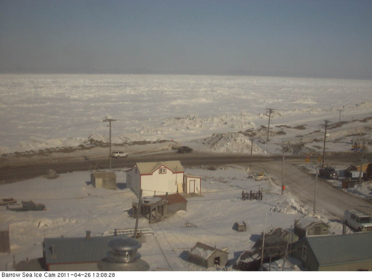
Parts of the North Slope dropped well below zero this morning. Lows included 20 below at Umiat and 13 below at the Ikpikpuk River gauge and Deadhorse. Barrow hit 10 below. This is nowhere near record lows: the record today at Barrow is 27 below set in 1924, and based on a much shorter period of record, the record low at Umiat for April 26th is 35 below in 1949. Photo from Barrow Tuesday afternoon looking northwest. Courtesy of the UAF Sea Ice Project

Sunday, April 24, 2011

Going…Going…


Snow depth at the Fairbanks Airport was down to 4 inches as of 4am Sunday morning. With a high temperature again near 60 today, either April 24th or 25th will be the last day with measurable snow cover. At the left is a plot of meltout dates for Fairbanks since 1930. I have adjusted for leap years in this plot. The red line is the five year running mean. Several things stand out here. First, over the full 82 years of data there is no trend. There is a cluster of early dates centered around 1940 and a cluster of late dates centered in the early 1960s. Claims of a trend toward earlier snowmelt based on the Fairbanks data are an artifact of starting the regression later than 1945 or so. Second, since the mid 1970s there is not much of a trend at all, though the lack of very late dates in the past 20 years is becoming noticeable.

Saturday, April 23, 2011

First 50 Degree Day

At noon at the Fairbanks Airport the temperature was 51F. This is the first 50 degree temperature since October 3rd. Hasta la vista, snow cover.

Alaska: it's not all the same


On the theme of the amazing difference between hills and valleys in Interior Alaska, here is a blast from the past. This composite photo is from September 2009. The bottom photo when I left home to go to work. The top photo when I got to UAF 30 minutes later. It isn't just that it was snow in the hills and rain in the valley. In fact, there had been very little precipitation at valley level.

Thursday, April 21, 2011

Snowmelt


The winter snowpack is going quickly now at low elevations. The snow at the Airport observing site is down to 10 inch depth and is increasingly patchy. Over the past 20 years, once the snow depth is down to 10 inches at the airport, it takes 4 or 5 days on average to melt out. Here on Keystone Ridge, it's a different story. There has been no loss of snow cover at all except right around the house. Here's a photo of the weather station from Thursday morning.

The forecast is for a substantial warm-up starting Friday, with highs in the 50s at valley level for the foreseeable future, and night time lows near freezing here on the ridge. This will chew up the snow in a hurry.

Tuesday, April 19, 2011

Sustained Temperature Anomalies


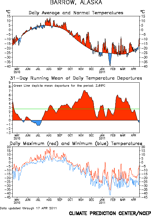
Here are plots of temperatures over the past year (through April 17) for Barrow and Fairbanks, courtesy of the Climate Prediction Center.

Of particular interest is the middle plot on each graphic. This is the 31 day running mean, so it smooths out the day to day variation and brings out the longer term patterns. The persistence of warmth at Barrow since last summer, and the mostly below normal temperatures at Fairbanks since December are obvious.

Sunday, April 17, 2011

Spring in Fairbanks


Sunday morning view in downtown Fairbanks, overlooking the Chena River. The snow on the south facing bank of the is going, while the ice on the Chena remains solid.

Wednesday, April 13, 2011

Still Winter on the North Slope


Another chilly morning on the North Slope. Lows Wednesday AM include:

Umiat: -34F
Ivotuk: -32F
Galbraith Lake: -22F
Atqasuk: -22F
Nuiqsut: -22F

This morning's NOAA-19 infrared image from 619AM shows the clear skies. Southwest of Umiat, in the upper Colville River drainage, is an area with surface temperatures around -40F. Not bad for mid-April.

Monday, April 11, 2011

When will the snow melt?

As of Monday morning, there was 19 inches of snow on the ground at the Fairbanks Airport.
This is somewhat above median for the date, and so how does this bode for melt out?

In the past 30 years, the Airport has had 19 or more inches of snow on the ground on April 11th seven times. Here are the years and the date of melt out (first day without measurable snow on the ground):

1985: 31 inches: May 9th
1989: 21 inches: April 25th
1991: 46 inches: May 7th
1992: 30 inches: May 7th
1993: 23 inches: Apr 24th
2000: 20 inches: April 27th
2009: 23 inches: April 29th
2011: 19 inches: ?

Based on just this small sample, you'd expect that 1) melt out will be later than the long term average of Apr 20th and 2) sometime in the last week of the month is the most likely.

Sunday, April 10, 2011

North Slope Spring


It's a lovely early spring weekend on the North Slope. Along the coast, temperatures in the teens below with 10 to 20 mph winds. Inland, light winds and cold. Through 6am Sunday, low temperatures include 33 below at Ivotuk, southwest of Umiat, 27 below at Umiat and Sag River and 24 below at Anaktuvuk Pass. Here's the web cam photo from Saturday evening at Umiat.

Updated: low at Umiat was -28F

Saturday, April 9, 2011

Spring Evening at Barrow


From the Sea Ice group at UAF, the view to west from Barrow 10:07pm Saturday. whaling season is approaching.

Thursday, April 7, 2011

Big Storm Churns On


The monster storm in the Bering Sea has brought a variety of not so spring-like weather to a large chunk of Alaska, with some details in this News-Miner article. The wind damage at False Pass is noteworthy, as being at the western end of the Alaska Peninsula they often gets strong winds. Here in Fairbanks-land there has been a little snow, but no great shakes.

The 4am ADT analysis shows the storm has started to weaken, but it's still packing a punch. At 10am ADT this morning St George, in the Pribilofs, reported a peak wind of 76 mph. The NOAA bouy (46045) that is a couple hundred miles west of the Pribilofs recorded a minimum measured pressure of 940.0mb at 9pm ADT Wednesday.

Update: Cold Bay wound up with a peak wind of 91 mph.

Wednesday, April 6, 2011

Big Storm


Here is the 4pm ADT Wednesday surface analysis from the Ocean Prediction Center. Offhand, I cannot recall such a deep storm in the Bering Sea in April. The major impact in Fairbanks-land will be to bring milder temperatures Thursday and Friday. Closer to the low center, both Atka and Adak reported a maximum wind gust of 72 mph Wednesday afternoon.

The Big Plunge


Here is an hourly temperature plot here on Keystone Ridge over the past day: as of 10am ADT Wednesday, it's running 25 degrees colder than 24 hours previously. The big plunge has been accompanied by gusty northwest winds and some light snow.

It will not last though; the models have been consistently forecasting it to warm right back up tomorrow (Thursday), as sometimes happen this time of year.

Saturday, April 2, 2011

Interesting March Factoid


March had the greatest average daily temperature range of any month of record in Fairbanks.
The average high was 25.4 and the average low was -10.8, for a mean diurnal range of 36.2 degrees. At the Goldstream Valley Coop site, the mean range was a stunning 43.6 degrees (29.5, -14.1).

Here on the ridge, the mean range was an almost exactly normal 14.0 degrees

This illustrates both the power of the sun and the efficiency of radiation cooling.

Friday, April 1, 2011

Nippy Start to April

Temperatures bottomed out as expected Friday morning. Low temperatures in the valleys included:

Fairbanks Airport: -15F
Goldstream Creek: -19F
Woodsmoke: -19F (near North Pole)
UAF West Ridge: -9F

Lows mostly just above zero at higher elevation, including+3F here on Keystone Ridge. As usual this time of year, the air mass will quickly moderate, so after a chilly night tonight, temps should be back to near or slightly above normal.

Thursday, March 31, 2011

March Ends on a Chilly Note


Much colder air moved into the central Interior Wednesday night, with Thursday afternoon temperatures 15 to 20 degrees cooler than the day before. And that was with of 100% sunshine, as the evening photo from UAF West Ridge shows the ground view. The NOAA-19 304pm visible image shows the view from above. High temperature for the last day of March 15F on Keystone Ridge and 21F at the Fairbanks Airport. April will start off on a chilly note: look for temperatures near 20 below in the cool valley spots by morning. No fooling. Photo credits: Alaska Climate Research Center, NWS Alaska Region

Monday, March 28, 2011

The Streak Ends

Snow started early Sunday evening in Fairbanks, ending the streak of precipitation free days at 28. This is the third longest sting of consecutive days without precipitation in Fairbanks since 1930. The longest is 33 days March and April 1993.

Friday, March 25, 2011

Power of the Sun


This month's sunny and dry weather has provided a vivid illustration of the increasing power of the sunshine. The graphic at the left plots daily max and min temperatures for the Airport and Keystone Ridge thus far in March. A couple of interesting items. First, inversion strength, as quantified by the spread in overnight low temperatures has been reasonably constant. However, high temperatures have been rising faster at the Airport, with the last week or so showing the standard (i.e. dry adiabatic) decrease in temperatures with elevation. This contrasts with early in the month, when the sunshine was unable to completely break the inversion.

Wednesday, March 23, 2011

Dry and Dangerous


Yesterday (Tuesday) was the 24th straight day with no precipitation at all at Fairbanks. This morning's 500mb analysis tells the story. Low flow, weak residual high aloft with a strong jet across the North Pacific. Plus, no moisture yet for convection.

The primary weather problem in Fairbanks area remains the freezing rain—from November. With dry and sunny weather for so long now, roads that had been snowpacked are now clear down to the ice. There has been patchy improvement the past few days as more pavement is exposed due to melting in some really sunny low elevation places, but other spots are just icier as water covers the ice surface. There was a 2-car fatal accident on Badger Road Monday afternoon directly attributable to ice from the November rain.

Sunday, March 20, 2011

Above freezing in Fairbanks


The mid cloud cover was solid until early Saturday evening, then it cleared right out. So it's back in the sunshine Sunday, and a return of the 40 degree diurnal ranges. So, with a low of -3F this morning at the Fairbanks, the stage was set for the first above freezing temperature since January 2nd. And waalaa, the high through 4pm ADT has been 36F.

Here on the ridge, up to 31F today with some drips off the roof.

Photo from Alaska Climate Research Center at UAF, about 530 pm Sunday, looking south

Saturday, March 19, 2011

Strange Sky


For the first time in almost three weeks, it's not sunny. The NOAA-19 polar orbiter infared image from 530am ADT Saturday shows an area of mid clouds west of Fairbanks-land. These have since moved in. What ever shall we do?

Friday, March 18, 2011

Tanana Sunrise


Sunrise Friday morning at Tanana from the FAA webcam. The sunny...cool and dry weather pattern looks to be changing...though not much threat of snow for most of the Interior. Temperatures are on the way up though.

Monday, March 14, 2011

Umiat Sunset


Mid-March sunset at Umiat, about 90 miles southwest of Prudhoe Bay. High today -18F, low this morning -39F.

Saturday, March 12, 2011

Diurnal Ranges and Inversions


Big high pressure, surface and aloft, remains over northern Alaska. Almost every day has brought bright sunshine to Fairbanks-land with no more than some wisps of high clouds, and the temperature of the airmass overall is not changing much. So this is a good set-up to look at the differences in diurnal temperatures between the lowlands and the hills. Plotted on the right are the range between high and low temperatures from the Fairbanks Airport and Keystone Ridge each day so far this month. The airport has consistently had more than twice as big a temperature range, generally around a 40 degrees swing, while Keystone Ridge is averaging about an 18 degree daily change in temperature.

The reason for this is not that the sun is providing more heating on the valley floor that 1000 feet higher. Rather, strong valley based inversion continue to form overnight, but there is now enough local heating from the sun to break that inversion, so some of the the daily temperature range in the valley is simply mixing down the warmer air above.

Wednesday, March 9, 2011

Big High Aloft


Wednesday was the ninth consecutive day of nearly cloud free skies over the central Interior. Big high pressure aloft is responsible; 3pm AST Wednesday; analysis from Environment Canada.

Thursday, March 3, 2011

Chilly morning in the Eastern Interior


Valley temperatures were in the 40s below in eastern Interior valleys Thursday morning, with lows of 45 below at Chicken, 44 below at Northway and Tok (the CWOP) and 40 below at Eagle. Still, bright and sunny. Image from Eagle, courtesy of the FAA.

In Fairbanks-land, 29 below at the Airport, 32 below at East Fort Wainwright and 35 below at Eielson AFB.

Wednesday, March 2, 2011

February

February 2011 will be long remembered in the annals of Fairbanks weather lore, with back to back storms that are close to "blizzards" as Fairbanks ever gets (which is to say, not that close). Still, 30 inches of snow any month in Fairbanks is a lot. Temperatures in the valley were actually not terribly far below normal, only 2.7 degrees at the Airport. Due to all the storminess, inversions were much weaker than normal, so it was much farther below normal at elevation. Here on Keystone Ridge, over seven degrees below normal for the month.